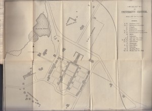
It’s not every day that you get to see a picture of the world just before it changed. But that’s what I found in my latest eBay finding, a copy of the Y.M.C.A. Student’s Hand Book to the University of Virginia, 1895–’96. Inside the book, after the title page and opposite the calendar of the year (more on that in a second), is a fold-out map of the University as it existed at the beginning of the 1895 school year.
It’s literally a peek backwards in time. The infirmary (now Varsity Hall) is on the map where it was built and stood until its move in 2005 to make way for the expansion of Rouss Hall for the McIntire School of Commerce (and Rouss, Cocke, and Cabell are not on the map at all). The original Dawson’s Row buildings dot the map in an arc leading away from Monroe Hill. The lost Jefferson Anatomical Building, here labeled “Biological Laboratory,” stands on the map alongside a pair of more modern buildings for Anatomy and Chemistry, both now lost to time. Memorial Gym is still the skating pond. Carr’s Hill is a set of wooden dwellings, with no sign of the president’s home that Stanford White built — of course, this was before the University had a president. Madison Bowl, and the original Madison House building, are just the “YMCA Campus.”
And of course, the Rotunda only has one set of east-west wings, and it has a big Annex.
It’s all poised on the brink of a monumental event: the destruction of the Rotunda Annex and the burning out of Jefferson’s Rotunda on October 27, 1895. In a day the University was turned upside down. Two years later the Rotunda would be rebuilt in a grand style, three academic buildings would close off Mr. Jefferson’s Lawn, and the unprecedented fundraising challenge would prove the last straw for the old faculty government model. Within ten years the University’s first president would take office. It’s a fascinating look back into a lost world.

One thought on “1895 Map of the University of Virginia Grounds”